


Septentrio’s 3D tech for road surveying

09 July 2021
XenoTrack said to capture a 3D topography of an entire area in a single shot
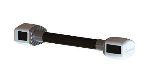 XenoTrack 3D road surveying technology from XenomatiX
Septentrio, a positioning solutions provider, and XenomatiX, which delivers solid-state-LiDAR technology for road management applications, have partnered to produce a LiDAR solution for road surveying.
XenomatiX will use Septentrio’s AsteRx SBi3 Pro+ GNSS/INS receiver to provide mm-accurate analysis of pavement conditions using global positioning coordinates.
Septentrio’s GNSS/INS (satellite positioning combined with inertial navigation) will form part of XenomatiX’s Road LiDAR called XenoTrack, designed for use by road surveyors and road management companies.
While traditional road scanning, based on laser profilers, relies on accurate GNSS/INS to stitch consecutive profiles together, the XenoTrack captures a 3D topography of an entire area in a single shot. The sensor fusion algorithms of the XenomatiX system combine techniques including visual SLAM (computer ‘vision’ technology) to obtain a seamless map of the road shape.
The Septentrio proprietary GNSS+ technology plays a key role in delivering the accuracy and reliability needed for XenoTrack. The technology ensures robust positioning – even when the sky is obstructed for an extended period, a built-in algorithm serves as an indicator of when it is best to give priority to other sensor input to maintain a high-quality solution.
STAY CONNECTED


Receive the information you need when you need it through our world-leading magazines, newsletters and daily briefings.
CONNECT WITH THE TEAM