


Hexagon offers digital twins of entire cities

22 September 2021
 Entire cities are now available as digital twins
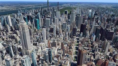
Hexagon has announced that it is now offering ultra-high-resolution 2D and 3D digital twins of major cities as an off-the-shelf product through the HxGN Content Program.
Announced at the Intergeo show, the company revealed that the Metro HD city data will expand the data stack to include high-definition true orthophotos, obliques, digital terrain models, LiDAR point clouds, 3D building models 3D meshes, and land use maps of entire cities.
Cities captured in 2021 include Munich, Cologne, Vienna, Milan, Amsterdam, Stockholm, Tokyo, Dallas, New York, Stuttgart and Frankfurt. More cities will be added in early 2022.
The program uses a hybrid urban mapping sensor, the Leica CityMapper-2, that collects LiDAR and aerial imagery. The derived products, based on the strength of each subsystem, are said to result in superior accuracy.
“By creating a 3D digital twin of the world, the HxGN Content Program is supporting the global need for geospatial data that enables insightful, data-driven decisions,” said John Welter, President Geospatial Content Solutions at Hexagon.
Hexagon says that the data consistency and flexible use terms of the HxGN Content Program makes it the ideal data source for artificial intelligence, machine learning, automatic feature extraction and large volume analytics.
Additionally, the 3D digital twins will enable city administrations and infrastructure providers to manage and monitor critical assets, assess and model risks, and support the visualisation of new infrastructure projects with the goal to create smarter, more sustainable cities.
STAY CONNECTED


Receive the information you need when you need it through our world-leading magazines, newsletters and daily briefings.
CONNECT WITH THE TEAM